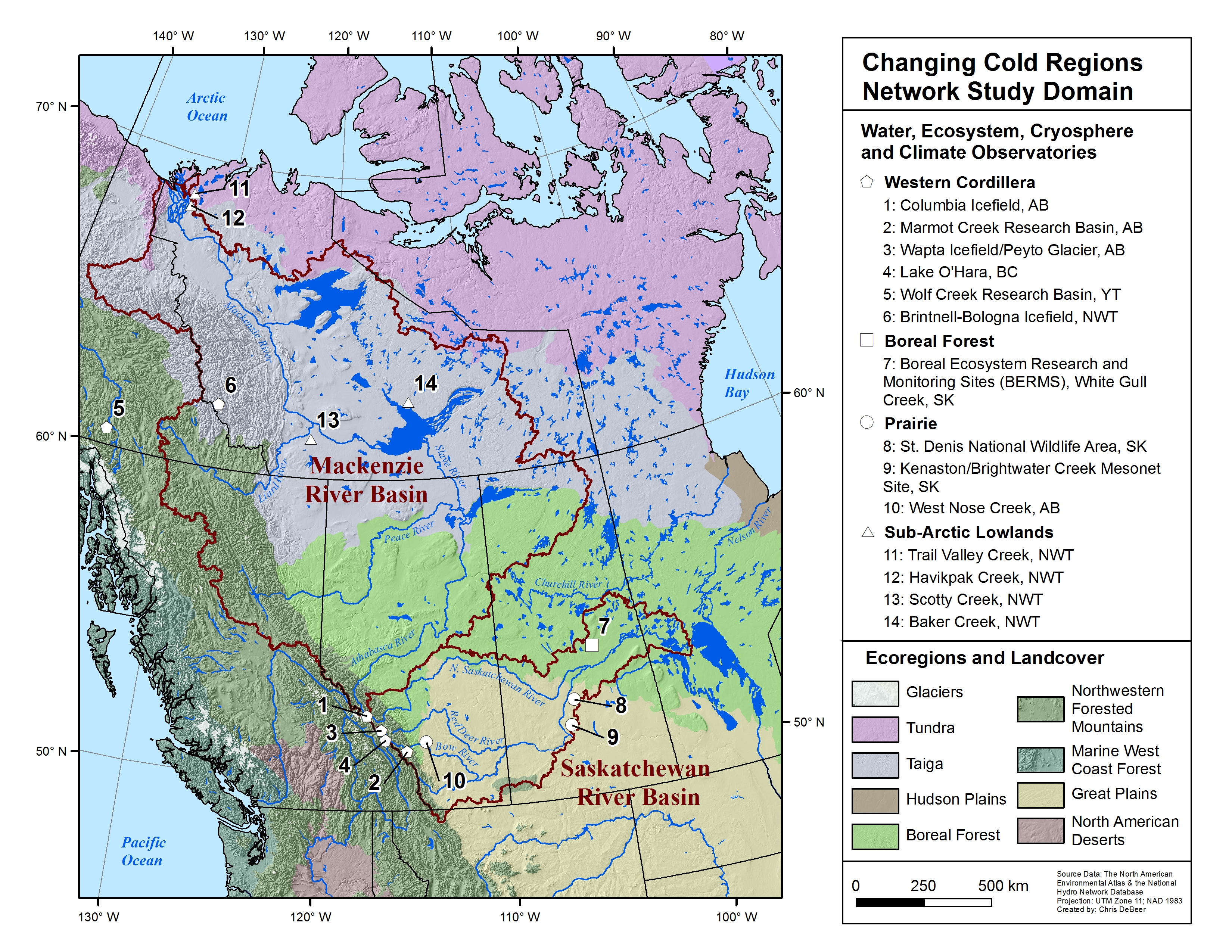
Water, Ecosystem, Cryosphere and Climate (WECC) Observatories

Map of the CCRN study domain and primary WECC observatories (click for larger image)

Through its members CCRN operates and uses a network of Water, Ecosystem, Cryosphere and Climate (WECC) observatories, distributed across the interior of western Canada.  These all contain long-term observational records and legacy datasets, including hydro-meteorological variables, remote sensing observations, LiDAR topography, and soils, geology, and vegetation characterization.  The WECC observatories exemplify the key cold region environments (Biomes) including the western Cordillera, Boreal Forest, Priaires, sub-Arctic Taiga Forest, and sub-Arctic Tundra. 

Information on the data available and the content archived within the CCRN's database is available through http://giws.usask.ca/meta.  Access to select datasets is available through http://giws.usask.ca/KistersWeb (Login name: public; Password: public), and further information on data can be found at http://www.ccrnetwork.ca/outputs/data

We have organized a special issue of the journal Earth System Science Data where we have published data from many WECC sites, and where the interested reader can find more details about particular sites.  Please see https://www.earth-syst-sci-data.net/special_issue901.html.        

  1. Columbia Icefield, AB
  2. Marmot Creek Research Basin, AB
  3. Wapta Icefield / Peyto Glacier, AB
  4. Lake O'Hara, BC
  5. Wolf Creek Research Basin, YT
  6. Brintnell-Bologna Icefield, NWT
  7. Boreal Ecosystem Research and Monitoring Sites (BERMS), White Gull Creek, SK
  8. St. Denis National Wildlife Area, SK
  9. Kenaston / Brightwater Creek Mesonet Site, SK
  10. West Nose Creek, AB
  11. Trail Valley Creek, NWT
  12. Havikpak Creek, NWT
  13. Scotty Creek, NWT
  14. Baker Creek, NWT

Study Domain

The Western Cordillera includes the southern cordillera headwaters exemplified by the Canada Foundation for Innovation (CFI) -funded Canadian Rockies Hydrological Observatory (including Marmot Creek) in the sub-alpine and montane forested Saskatchewan River headwaters, Lake O'Hara alpine sites and the Natural Resources Canada (NRCan) -funded Columbia Icefield Glacier-Climate Observing System in the glaciated Athabasca headwaters, Alberta. This provides a cluster of >25 high elevation snow/ice and hydro-meteorological stations in nested gauged catchments. In addition, the NRCan-funded Brintnell-Bologna Icefield, NWT and the Yukon Environment-supported Wolf Creek Research Basin, Yukon, exemplify glaciated and nonglaciated sub-arctic northern cordillera headwaters of the Mackenzie River. Unique observations of alpine and sub-alpine sub-surface storage and release are available from Lake O'Hara and Marmot Creek. Alpine treelines in this area are advancing in elevation where geomorphology and microclimate permit. Provincial, territorial and federal observation stations for flood forecasting, climate and fire prediction are clustered at both high and low elevations in the region. The archive for Marmot Creek covers most of 50 years and for Wolf Creek covers 20 years.

WECC Observatories

Columbia Icefield

Marmot Creek

Peyto Glacier

Lake O'Hara

Wolf Creek

Brintnell-Bologna Icefield 


The western boreal forest study area of CCRN traverses the latitudinal and altitudinal extents of boreal forests in Canada and the range of permafrost conditions across which these forests exist (nonpermafrost through to deep, continuous permafrost). Western permafrost-free boreal sites include the Boreal Ecosystem Research and Monitoring Sites (BERMS) in Saskatchewan that derive from the mid-1990s NASA-Canada Boreal Ecosystem-Atmosphere Study (BOREAS) and were subsequently expanded to the Environment Canada (EC) BERMS Programme. These sites in the Boreal Plains ecozone are characterized by heterogeneous forest types interspersed with wetlands and frequent wildfire disturbance, and include Black Spruce, Aspen, Jack Pine and Fen. Additional data sources in this region include Northern Alberta flux tower sites, developed in collaboration with the Oil Sands industry, as well as provincial and federal observation stations for climate and fire prediction.

WECC Observatories

Boreal Ecosystem Research and Monitoring Sites (BERMS)


Includes the upland St. Denis National Wildlife Area (SDNWA; EC) of internally drained wetlands, cultivated fields and pasture; the semi-arid West Nose Creek groundwater recharge area; and the Kenaston/Brightwater Creek mesonet site of lowland level pasture and cultivated grassland. A soil and groundwater observatory along with flux towers is established here in collaboration with the Canadian Space Agency (CSA) and NASA. Specialised soil moisture measurement arrays, cosmic ray soil moisture probes, a geological weighing lysimeter coupled to a network of groundwater observation wells, atmospheric measurements using large aperture scintillometer and Sonic Detection and Ranging (SODAR) and weather radar provide a unique concentration of measurements in a Canadian prairie environment. All sites are in the Saskatchewan River Basin (SRB); SDNWA has a 50 year archive.

WECC Observatories

St. Denis National Wildlife Area

Kenaston / Brightwater Creek

West Nose Creek

Key study sites are located at the northern (Trail Valley and Havikpak Creeks) and southern (Scotty Creek) margins of the Taiga Plains ecoregion along the Mackenzie Valley. In addition, between these end-member sites we have a network of 204 representative permanent sample plots (PSPs), each with historical and contemporary data on vegetation (ground and canopy), soil properties and active layer thickness. These existing observatories, along with Wolf Creek (Western Cordillera), are ideally suited for the study of permafrost thaw-induced changes to ecosystems and the resulting impacts on surface-atmosphere interactions and hydrology, as they cover a wide latitudinal and altitudinal range and therefore a wide range of permafrost ecosystem characteristics, from discontinuous permafrost characterised by a forest wetland mosaic to continuous permafrost overlain by forest, grading into tundra. In addition, these sites are located in areas where permafrost is very sensitive to change.

WECC Observatories

Trail Valley Creek

Havikpak Creek

Scotty Creek

Baker Creek